Recently Rated:
Stats

How many Reservoirs are there in the Elan Valley?
Oddly there could be several different answers!
To clear one thing up from the outset, I shall say we will include the 2 reservoirs in the Claerwen valley as being a part of the Elan Valley scheme.
In the original plans in the 19th century there were to be a total of 7 Dams, 4 in the Elan Valley and 3 in the Claerwen valley. However, of the 3 in the Claerwen valley only the foundations of the first one was built, Dolymynych. It was intended that 2 more dams would be built at a later date, but these plans were replaced in the 1940's with the much bigger scheme to build the Claerwen dam whose capacity is similar to the whole of the rest of the reservoir system put together.
Here is a description of the dams in the Elan valley scheme, from the top of the Elan river valley.
Craig Goch Dam has the rather picturesque bridge across it, and loos are available at the head of the railway track /cycle path where there are views over the Pen y Garreg reservoir. At the head of the reservoir is Pont Elan, possibly the remotest location for a traditional annual show and sheep dog trials, up stream of here is a rare example of river meanders in an upland setting, and dramatic glacial deposits at the foot of side valleys, clearly seen along side the road to Cwmystwyth.
Craig Goch Dam.
Pen y Garreg reservoir has an island that would not look out of place on a Scottish Loch and the Dam has a central tower which can be visited by walking along inside the Dam, on Dam open days when donations are collected for 'water aid'. Nearby are the Penbont house tea rooms and B+B. Below the dam are a selection of woodland walks.
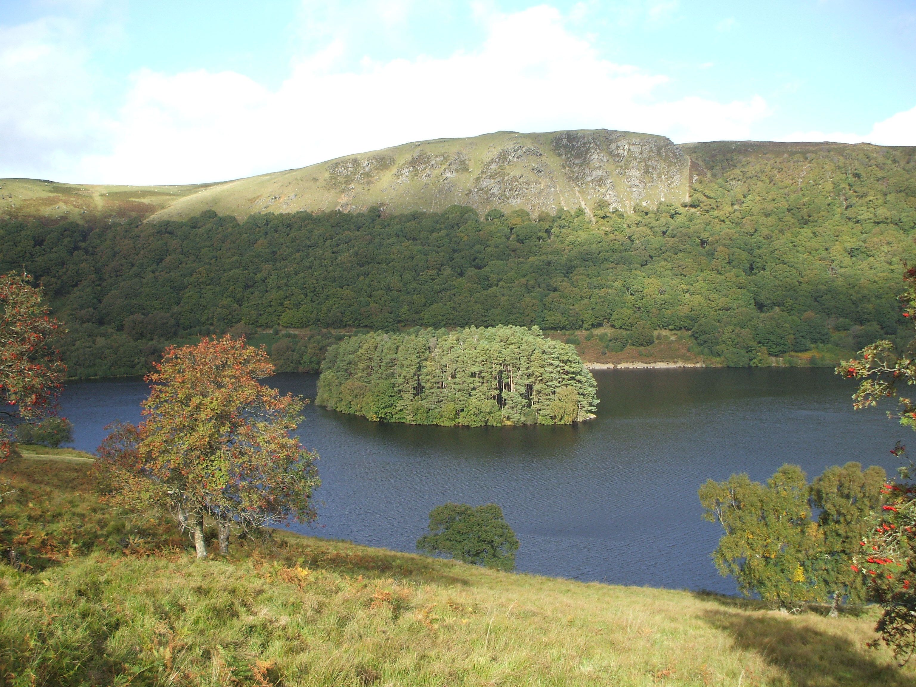
Autumn in the Elan Valley - Pen y Garreg reservoir with its Island.
Garreg Ddu dam is hidden under water, below the road bridge between the Foel tower and the Nantgwyllt church. Its purpose is to maintain a minimum water level at the Foel tower, the outflow of the scheme to carry water to Birmingham. In exceptionally dry weather the level in Caban Coch Reservoir can fall low enough to expose Garreg Ddu dam, and it is only then that these 2 reservoirs appear to be separate bodies of water, normally they could be seen as being 1 reservoir.

Garreg ddu dam at a time of exceptionally low water. The water in the foreground is Carreg Goch reservoir. (picture from Wikipedia).
Caban Coch Dam is the first dam that most people would see approaching from Rhayader and the visitor centre, it is the largest of the original dams and there is a huge quarry beside it where stone was taken for in - fill for the construction of the Dams, the local stone was too hard for masons to work so stone was brought in from quarries in south Wales for the facing stones, every one of which is carefully dressed.
In the Claerwen Valley, the Dolymynach dam was begun in the 1890's so that water from the Clearwen river could be directed along a tunnel to just 'up stream' of the Garreg Ddu dam in the Elan Valley, to supply the Foel tower outflow. It was never intended to be completed at the time of the original scheme, but literally laid the foundations for expansion as and when it should be needed. As plans later changed, this means Dolymynych is the one body of water in the valley which always maintains the same level, benefiting wildlife with wetland areas at its fringes,and saving several farms from flooding.
In the 1940's it was decided that a single much larger dam could be built higher up the valley, instead of the 3 that were planned 50 years before. The Clearwen dam was built in a similar style to the older dams and has a bridge over the top. The reservoir floods an upland valley that would have been largely similar in appearance to the upper part of the Elan valley.
The View from Claerwen Dam.
There is another dam which has an unusual place in history, in fact just the remains of Nant Y Grow Dam now exist, there is now no reservoir as such. Originally built for a water supply for Elan village and the work shops during construction, it was blown up in the second world war as a part of the preparations for the Dambusters raids.
So there are 6 Dams, including Garreg Ddu - the one which is almost always submerged by the combined waters of Caban coch and Garreg Ddu reservoirs and including Dolymynych which is really only the foundations of an unfinished dam, but not including the remains of Nant y Grow Dam.
Since 1997 each Dam has been producing hydro electricity from turbines built at the base of the dams.
The question was "how many reservoirs?" and you may have noticed I have answered with the number of dams. The number of reservoirs could be said to depend upon the level of Caban coch / Garreg Ddu, but we'll count it as 2. So there are 6 Reservoirs; Craig Goch, Pen Y Garreg, Garreg Ddu, Caban Coch, with Doly y Mynych and Claerwen in the Claerwen valley.
In the 1970's, plans were made to massively increase the size of Craig Goch. This would have been such a massive dam it would have again roughly doubled the size of the whole scheme, dwarfing Claerwen and requiring a second dam to capture waters flowing into the upper Ystwyth to the North west. The plans were abandoned as projections for water requirements reduced and with increasing awareness of environmental issues.
For more information visit http://www.elanvalley.org.uk/dams-reservoirs/
If you are thinking of visiting Wales, contact www.cambriansafaris.co.uk and www.facebook.com/cambriansafaris
 Yesterday I (Cambrian Safaris) was asked by someone who wanted to write something for Powys County Council to suggest some examples of 'hidden gems' along the boundary of Powys / Ceredigion in the Cambrian Mountains. This was my answer.
My perspective is more from the Ceredigion side but one of the problems with promoting the Cambrian Mountains is the fact that while a large proportion of the wilderness its self is in Ceredigion, its always been difficult getting people each side of the mountains to work together. Ceredigion is too coastal orientated, Powys isn't interested in half of the Cambrian Mountains because its in Ceredigion.
Historicity the Mountains were quite a barrier to communication, I used to talk at Llywernog Silver lead mine about how it would have been a bit like the Wild West for people coming here for the fist time hundreds of years ago. I think its still like that now for some, unpronounceable place names, narrow roads they dare not venture along, - the unknown in general.
If you travel from England into Wales and across Powys, there is a great Geological change, where ever you enter Wales you are suddenly surrounded by Hills, but to travel from Powys into Ceredigion you really have to mount an expedition across the mountains.
The western boundary of Powys - certainly where it borders Ceredigion, is very much hidden in the heart of the hills. Where it comes down to the coast near Machynlleth, people travelling along the A487 must be aware they are squeezed between the mountains and the sea. If you turn in land anywhere along that stretch, the roads are tiny.
Travelling the A44 to Aberystwyth, you climb as high as the mountain passes in the Lake district, passing from the Upper Wye valley at Eisteddfa Gurig the road passes through a narrow gap as if into another world, the bends on the way down to Dyffryn Castell giving dramatic views of a new valley, then on through Ponterwyd and past Bwlch Nant Y Arian where there is a fabulous view to the coast.
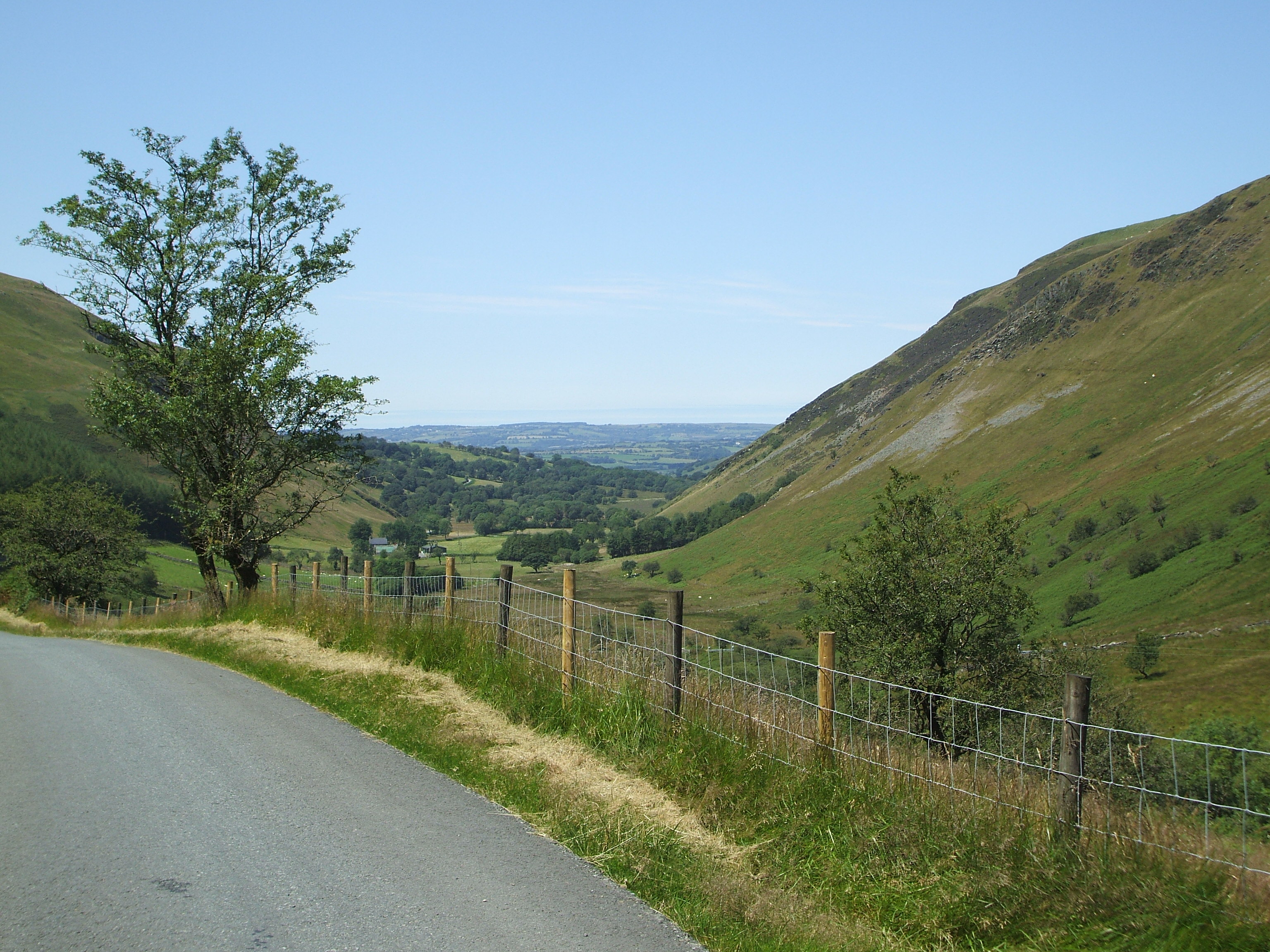
If you take the old coach road from Kington to Aberystwyth, between Rhayader and Devils Bridge you climb to 1600 feet with views of the Arans and much of Northern Powys, you drop into the upper wilderness of the Elan Valley and again, there is a tight pass into the upper Ystwyth Valley as you enter Ceredigion. The Ystwyth changes character at almost every turn in the road, magic around every corner. (Part 2 of my trip up the Ystwyth is coming soon!) Over the hill and past "The Arch' there are views to the sea and Aberystwyth.
If you head west from Builth Wells on the Main Trunk road which heads for Llandovery, only a few people will turn off at Beulah and follow in the footsteps of the Drovers returning to Ceredigion. The Abergwesyn Mountain road is 20 miles or so of single track road, starting off up thebeautifulIrfon Valley with Oak woodlands typical of many steep sided valleys in mid Wales and then climbing the 'Dev ils staircase" into the forestry, and plunging down in to the mighty Towi valley, turn left here for the spectacular Llyn Brianne reservoir, or right - if you have a very capable 4x4 - to follow the famous 'Strata Florida' green lane (rough track) to the monastery of that name. The regular road climbs 2 more summits, reaching over 1,500 feet, with views to the Brecon Beacons, before plunging down to Tregaron in the Teifi Vally;
Heading out of the mountains towards Tregaron, here the Drovers would be nearly home.
Skirting the south of the Cambrian Mountains, roads from Llandovery and Llanwrda head for Lampeter, passing the Dolaucothi Gold Mines. Its possible to explore the lower Towi valley up to Llyn Brianne and a variety of roads from the upper Cothi valley over to Llanddewi Brefi and the Teifi Valley.
For me, the greatest 'hidden gem' is the diversity of Landscape and the regularity with which the view changes, the appearance of the Landscape changes. For those who venture west, the reward is the surprise around the next corner.
Its not Just about specific places, there are favourite spots of course, but visitors could waste a lot of time trying to find specific locations and miss some of the hidden gems along the way and thestories to go with the drama of the scenery.
Mid Wales has a huge amount to offer, but the Cambrian Mountains don't have the same profile and image for promotion as the better known National Park areas in the North and South of Wales.

Part 2! ( for part 1 see my post on 14th Aug ) I often say that mid Wales must have been a little bit like the 'wild west' for the people who came here to work in the mines, this is about them, from one of the old fact sheets written by Peter Lloyd Harvey in the 1970's for the old Llywernog Silver Lead mine Museum. Its in part about people who moved to another country to work in new lands.
The Mining Communities.
The following villages in Cardiganshire traditionally had a high proportion of lead mining families living within them. From north to south these were:- Tre'r-ddol, Tre Taliesin, Talybont, Elerch (Bontgoch), Penrhyncoch, Penbontrhydybeddau, Cwmsymlog, Cwmerfin, Darren, Salem, Goginan, Cwm-brwyno, Llywernog, Ponterwyd, Ystumtuen, Devil's Bridge (Pontarfynach), Aberffrwd, Trisant, Cwmystwyth, Pontrhydygroes, Yspytty Ystwyth, Llanafan, and Pontrhydfendigaid. Certainly in the early years, the Cornish communities kept apart from the local inhabitants. Big concerns, such as the Lisburne Mines Company, actually built acc-ommodation for their own 'key workers' from Cornwall. New Row, between Trisant and Pontrhydygroes, is an example and a gravestone in Goginan village tells of a long forgotten terrace known as 'Cornish Row.' Not only did the Cornish live apart from the Welshmen, but they upheld their own peculiar brand of religion; Wesleyan Methodism. The very first Wesleyan chapel to be built in the Cardiganshire circuit was provided by the Lisburne Mines Company, close to New Row and the giant Fron-goch Mine complex. Later, chapels were also built for the mining communities at Goginan, Cwmystwyth, Pontrhydygroes, Tre'r-ddol, Cwmsymlog and Ystumtuen.
The Mine 'Captains.'
These men were the elite of the mining industry. In the village communities, as in the dark depths of the mine workings, they commanded the utmost respect. Many were Cornish, or of Cornish extraction, but as the industry expanded in the 1850's, their ranks were joined by local men such as John Hughes of Talybont. In an age of illiteracy, the Captains kept the mine ledgers, surveyed the workings and paid the men. Some, such as Absalom Francis & Sampson Trevethan, found time to write numerous letters in the columns of the 'Mining Journal', usually describing the hectic activity in the ore-field and imploring investors to 'venture' a little more capital in the Welsh hills! The captains acted as consultants, inspected mining properties and reported on their merits, and inevitably said the right thing as far as the shareholders were concerned. Apart from this tenancy toward the 'overstatement', they were nevertheless good fundamental engineers who understood the pumps & winding gear, knew perhaps a little less about geology and ore-dressing, and were the absolute 'king-pins' of the entire industry. The names of some of these men have been preserved within the faded pages of the 'Mining Journal' and in other lists of mines & Inspectors Reports. These were some of the better-known mine 'captains' of Cardiganshire:-
Absalom & Mathew Francis (from Perranuthnoe, Cornwall), Henry Tyack, Michael Barbery, George Pearce, Sampson & John Trevethan (from Chacewater, Cornwall), Arthur Waters, Thomas Pascoe, James Sanders, John Trewin, Robert & Richard Northey, James & Henry Boundy, James Lester, Andrew Williams, John Davis, Charles & Richard Williams, James Raw, Richard Harvey, James & John Paull, Richard Clocker, William Michell, Thomas Ball, John Williams, John Hughes, James Corbett, John Kitto, Thomas Kemp, Thomas Hodge, John Tregonning, John Glint, John, James, Peter & Thomas Garland, Richard Rowse, John Owen, Nicholas Bray, John H. Croucher, Jonathan Pell, Joseph B. Rowse, Robert Uren, William Brammell, John Ridge, Thomas & Lyle Glanville, Edward Evans, Richard Claridge, & Robert R. Nancarrow.
The System Of 'Cornish Mining.'
Wherever the Cornish miners went, they carried with them a whole system of mining practice which had evolved in the tin and copper districts of the West Country. This 'standardization' not only involved terminology, but also such things as pumping plant, the 10-fathom interval in-between levels and the method of employment of the labour force. Not all the employees on a mine were miners. There were tributers, tutmen, labourers and ore-dressers, besides specialists such as stone masons, carpenters & blacksmiths, all under the direction of one or more Agents or Captains. The following account, written in 1868, gives a clear description of the differences between the groups of workers:-
'There are three classes of miners - those who work on the surface, dressing ore etc., who are paid a weekly wage; those who work on "tribute", and those who work on "tut-work." Of the first we say nothing, except that they consist chiefly of bal-maidens and children, - the former receiving about I8s. a month, and the latter from 8s. to 20s., according to age and capacity. In regard to "tributers" and "tut-workers", we may remark that the work of both is identical in one respect - namely, that of hewing, picking, boring, and blasting the hard rock. In this matter they share equal toils and dangers, but they are not sub jected to the same remunerative vicissitudes.
Tributers & Tut-workers.
When a man works on "tribute" he receives so many shillings for every twenty shillings' worth of ore that he raises during the month.... If his "pitch" turns out to be rich in ore, his earnings are proportionally high; if it be poor, he remains poor also. Sometimes a part of the mineral lode becomes so poor that it will not pay for working, and has to be abandoned. So as little as a shilling may be the result of a "tributers" work for a month at one time, while at another time he may get a good pitch, and make 100 or 200 in the same period.
The "tut-man" (or piece work man), on the other hand, cuts out the rock at so much per fathom, and obtains wages at the rate of from 2-IOs. to 3 a month. He can never hope to make a fortune, but so long as health and strength last, he may count on steady work and wage. Of course there is a great deal of the work in a mine which is not directly remunerative, such as "sinking" shafts, opening up and "driving" (or lengthening) levels, and sinking "winzes." On such work tutmen are employed. The man who works on tribute is a speculator. He who chooses tut-work is a steady labourer ........'
Home Life.
The Cardiganshire miner, when not crawling around in the damp and dark of a mine level, was often-as-not a small-scale farmer, earning a supplementary living from a patch of marginal land. All around Llywernog, Ponterwyd & Ystumtuen you can see the ruins of these tiny small-holdings which once provided a rudimentary home for the miners and their families. This fact was an advantage to mine owners for it enabled them to keep wages low, but it could also cause high absenteeism during times of potato planting and at harvest time. There was also a great tradition of peat harvesting from the numerous 'turbaries' throughout the mountains; peat providing the main source of heat for the home and for cooking. The most prolonged stoppages in the mines occurred in September when a whole succession of harvests of one sort or another might keep the men occupied for eight weeks or more. The 'Mining Journal' of 1877 stated that in Cardiganshire it was still the general custom for men to combine a 40-hour week at the mines with small-scale farming, and that employment, therefore, tended to pass from father to son. To many of the local men, mining was merely a means of earning enough to pay the rent for the small-holding. This was in complete contrast to the Cornishman, who was a professional 'career' miner and prepared to stake everything on the gambling element of the 'tribute' system.
Barrack Life.
Many of the Cardiganshire lead mines were located high up in the mountains and far away from the village communities. Barrack accommodation was often provided for the miners, who spent the whole working week away from home. The 'barracks' became a traditional part of the working life of the lead miner, a tradition that survived right up till the early part of the 20th century at Bryn-yr-Afr, Cwmystwyth & Bwlch-glas Mines. The men left home before dawn on Monday morning and walked up the little footpaths that led from the villages into the hills, taking with them all their food supplies for the week. At the barracks they slept two or more to a bed, bedclothes were rarely washed and there were few, if any, sanitary arrangements. Where a 3-shift system was being operated, the beds were never empty. It is hardly surprising that tuberculosis was one of the most common complaints amongst lead miners.
EPILOGUE.
After the great slump of the 1880's, migration away from the mining area of Cardiganshire gathered pace. Gradually, the old mining villages became depopulated. Chapels & schools closed down and decaying small-holdings dotted the landscape. As a breed, the Cardiganshire miner is no more, but his memory will continue to haunt the green hills of Mid-Wales for many generations to come.
-
1981. SPLH.

I intend to write a number of times on a variety of subject areas relating to the old mines in mid Wales when I can get around to it, but I've just come across one of the old fact sheets written by Peter Lloyd Harvey in the 1970's for the old Llywernog Silver Lead mine Museum. Its in part about people who moved to another country to work in the mines... Here's the first part. (very slightly edited by me.)
The Cardiganshire Lead Miner, How he lived and worked.
Introduction.
The mines of old Cardiganshire were often located in the most remote places, high up in the mountains and far away from the existing centers of population along the coast and in the lowlands. At each period in the development of the industry, labour was imported from other mining areas, not only in Britain, but overseas as well. Completely new villages grew up to serve the needs of the mining folk, creating a pattern of settlement which strongly contrasted with the local agrarian society. The 'typical' lead miner may have been Cardiganshire born and a part-time farmer; he may equally well have been from distant Cornwall or Derbyshire, and a professional, full-time, mine worker. In this Factsheet we try and take a closer look at this hardy breed of men & women who pioneered metal mining in the Plynlimmon Mountains of Mid-Wales over the centuries.
The Immigrants.
Cardiganshire (Ceredigion) is still one of the most remote of all the Welsh districts. Traditionally, few route ways traversed the barrier formed by the 'Cambrian Mountains' and the easiest line of communication lay seawards through the western oceans. The area is still one of the strongholds of the Welsh language, and in former times, most of the local inhabitants were only Welsh speakers. Against that background it can be seen that any immigration was bound to cause something of a social upheaval. Mining did just that and left a profound mark on the little communities. The first, and perhaps the most strange, influx of miners came in the 16th century, following the incorporation of the Elizabethan 'Society of the Mines Royal.' Queen Elizabeth brought in two German mining experts to help in the development of British mineral resources. Daniel Hochstetter and Christopher Schutz were instrumental in recruiting many more of their fellow countrymen for field operations. When the Cwmsymlog Mine was being worked by 'Customer' Thomas Smythe between 1586 and 1597, the majority of the workers were of German origin, confusingly referred to as 'Hollanders.'
Convict Labour.
In the I8th century, the 'Company of Mine Adventurers' tried an experiment by employing '27 condemned criminals' from prisons on the Norfolk Circuit. Life must have proved a great deal harder than being in gaol and at least two escaped. A plan to bring captured 'Pyrates' to the mines of Mid-Wales was scotched by a public outcry!
Derbyshire miners started to appear in Cardiganshire at this time, including John Paynter, John Roose and Sir Thomas Bonsall of Bakewell. Another, Job Sheldon, was Mayor of Aberystwyth on no less than 12 occasions between 1804 and 1833. The rich discoveries of lead at the Old Darren Mine in 1731 were made by a Cornish engineer called Edmund Moore. He and his small band of fellow Cornishmen had a brief 'skirmish' with Flintshire miners over the disputed ownership of the Cwm-Darren Level.
The Napoleonic Wars .
The Napoleonic Wars started in 1793. The effects on lead mining in Cardiganshire were disastrous, for not only did the traditional overseas markets disappear overnight, but the pool of skilled labour was called away to fight with Nelson & Wellington. After 1815, growing numbers of miners from the West Country moved in to fill the vacuum, although the industry was still in a depressed state.
Cornish management moved in too, not only in Mid-Wales, but also in Flint & Denbigh. In 1824, the Williams family of Scorrier House, near Gwennap in Cornwall, arrived complete with Cornish mine 'Captains' and most of their underground staff. They appear to have been accepted by the few Cardiganshire miners still left, unlike their counterparts in Flintshire who deeply resented the presence of the Cornishmen. Two years earlier, Sir George & Sir Thomas Alderson, arrived at the great Cwmystwyth Mines bringing with them a small army of Yorkshire lead miners. One of this group, James Raw from Swaledale , was to become one of the best-known of the Cwmystwyth mine 'Captains'. The Raw family still Farm in Cwmystwyth.
The Cornish.
1834 saw the arrival of the biggest ever influx of Cornish miners under the general direction of John Taylor and his engineer sons. Suddenly, everything became Cornish, the surnames, the entire 'language' of mining', even Cornish-made machinery was shipped in to Aberystwyth from such places as the Perran Foundry, and Sandys, Vivian & Company. The first official Census dates from 1851 and shows us that there were 343 Cornish & Devon born people then living in the mining district of Cardiganshire, together with 424 from Flintshire. By 1871, the ratio had changed in favour of the Cornish with 523, as compared with 245 from Flint and 173 from Yorkshire. The Cornish domination of the industry continued until the great slump of the I880's. Many Cornishmen returned home but there were also those who stayed, inter-marrying with local Welsh families. Alf Jenkins of Yspyty Cynfyn is one such Cardiganshire-Cornishman, whose family name was Trevethan in the I9th century.
THE 'LANGUAGE' OF MINING.
In the I8th C., most of the technical terms used in the mines of Mid-Wales were based on those used in the ancient 'High Peak' lead mining district of Derbyshire. For example, Bunnings were timber stagings on which broken material, or Bouse, was allowed to accumulate in the stopes; cranches were unworked pillars of vein; the forefield was the furthermost part of the workings on the vein; a Liberty was the district in which the mineral lord could grant the right to work minerals; a sough was a drainage tunnel; a stemple was a support timber; a stowe was a small hand windlass, and a waygate was a main haulage way. In addition a mine was always operated under the direction of agents or managers, and the unit of underground measurement was the yard.
Now see what happened after the Cornish 'invasion' of the Mid-Wales mines in the I820's. A mine was managed by a Captain, and the account ledgers (kept in the Count House or office) were looked after by the Purser in a Cost-Book Company. Ore was hoisted in an iron bucket, or kibble, the forefield became the fore breast , the sough became an Adit, the stemple became a stull and depths and horizontal distances were measured in fathoms. The nautical flavour of the Cornish mining 'language' was the result of the intermingling of the sea and work in the bal (mine). Nowhere in Cornwall was the sea very far away and in places like St Just and St Agnes, miners were often part-time pilchard fishermen too. The standardisation of terms made good common sense.
To be continued!
Hi everyone. I intend to write something on here once or twice a week, because I enjoy telling people about places and the stories which go with them. I have an ulterior motive of course, to promote my business, 'Cambrian Safaris' which I'll push more directly another time. I have a separate identity on here for the business, where I will write about tours and places of interest.
First a little bit about myself.
I was brought up in the south east of England, but my association with Wales started with the majority of childhood holidays being taken in Cardiganshire (as we knew it then).
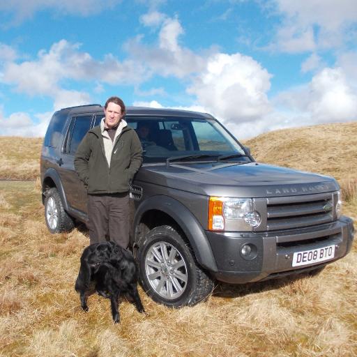
I am married to Hester, a Dutch lady I met at a the Dolaucothi Gold Mine (more about that someday) and we have 2 children, Dylan, 13 and Bethan,11. We live on the edge of a small village about 11 miles from Aberystwyth, a little way up in the hills, and have a few chickens and 2 Dogs, (Flatcoated retrievers). There are some great views to Cardigan bay from just up the road.
Places have always been important to me, perhaps partly because of the experiences I have had in those places. A theme I will no doubt expand upon in the future is how the place where you live the landscape in particular- influenced people and their fortunes in the past.
In my 'youth' I spent the best part of a couple of years in the Lake District, working with the National Trust... I've started writing about that somewhere... For the greater part of the last 17 years I worked at the Llywernog Silver Lead Mine, conducting guided tours through the mine and telling people what it was like living in the 'wild west' of Wales for the people who came here to work in the mines. I will definitely write about this a number of times no doubt, featuring how the Geology and Geography of an area influences peoples led their lives in the past.
Mid Wales has been my home for about 20 years now, including my time as a student in Aberystwyth. To me one of the things that is most special about the area is the variety in the Landscape.
The Wild west of Wales.
Ceredigion has a bit of everything, from a varied coastline, deep river valleys, green farmland and the Cambrian Mountains. The coast, from the sand dunes at Ynys las and Borth Bog, to the raised beaches at Llanon, and the cliffs from New Quay to Cardigan covered in nesting sea birds, is largely designated as a Heritage coast, with special wildlife protection stretching out to sea. Dolphins, Porpoises and Seals, are regularly seen here, boat trips are on offer from New Quay, and crab and lobster boats operate from here too.
The Cambrian Mountains guard the eastern side of the county, although they are a fraction of the size of the Rockies, they have always been a barrier to communications, nowadays the barrier is more psychological, in the past communities along the coast had more trade with Ireland than England.
The southern half of the county has more of a lowland character, although it is still pretty hilly with some deep valleys cutting into it, it is covered largely in farmland with - I believe mostly good grazing. The valley of the River Teifi runs along the foot of the mountains from Pontrhydyfendigaid, Tregaron and Lampeter, and runs down to the coast at Cardigan, (Aberteifi) through Newcastle Emlyn.
In the northern half of the county the Cambrian mountains stretch down to the coast, these hills are crossed by a number of fault lines along which the remains of over 100 old Silver Lead mines can be found, a mini 'wild west' with the stories of the people who came in search of riches here over the last 4000 years.
If you work your way up a valley like the Ystwyth, the landscape changes dramatically every few miles, from a broad open valley to an Alpine like V, a deep gorge and opening up into a forested estate, more farmland, heavily mined hillsides, and high wide open moor land, all in the space of about 15 miles.
This merely touches on the riches of a little known part of the world. It has long frustrated me that Wales is always divided into 'north' and 'south' when described from outside, tourism wise its all about the National Parks. Mid Wales is very much a non entity, and Ceredigion is barely heard of in the outside world,which is a very great shame. Things are hopefully changing, Ceredigion is slowly becoming known as a specialist food producer, Welsh Lamb, farmhouse cheeses, lobster, even wine!
Part of my idea for Cambrian Safaris is to play a small part in showing the rest of the world that mid Wales has something to offer, spectacular landscapes and the history and stories that go with it.

This week is the week of the Royal Welsh Agricultural show. For anyone who lives in rural Wales it is a highlight of the year, if any schools have not yet broken up for the summer holidays there will be a notable level of absenteeism! Farming families strive to get the hay crop in in time this year it would have been easier than for about the last 6 years thanks to 4 weeks dry weather and take a weeks holiday to camp on site or nearby.
For anyone not wanting to go to the show, its worth avoiding Builth Wells, which can be difficult as Wales' 2 major north south trunk roads cross here, traffic gets waved into car parks, I once over heard some poor Japanese tourists ask if this was the way to London after they had been herded into a car park, I dread to think how long it took them to get out!
The first Royal Welsh Agricultural show was held in Aberystwyth in 1904, and for the first half of its history the show was hosted by different counties at different locations around Wales each year. The tradition of the show being 'hosted' by different counties has continued, but since 1963 the show has taken place at Llanelwedd, across the river Wye from Builth Wells. In 2013 Anglesey is the 'featured county'.
http://www.rwas.co.uk/fifty-years-at-llanelwedd/
http://www.facebook.com/RoyalWelshAgriculturalSociety
I'm not sure if BBC iplayer works outside the UK...
http://www.bbc.co.uk/iplayer/search?q=Royal%20Welsh%20Show%20(2013)
And for more tv highlights there's S4C http://www.rwas.co.uk/television-highlights-1/
Its not just an Agricultural show for farmers, anything and everything to do with the countryside is there, from falconry displays to fishing demonstrations, crafts, vintage machinery, an incredible variety of food to sample, I always look for ostrich burgers, venison, wild boar as well as Welsh lamb and beef... and fabulous farm cheeses and Ice cream, so its a glorious and tiring - family day out.
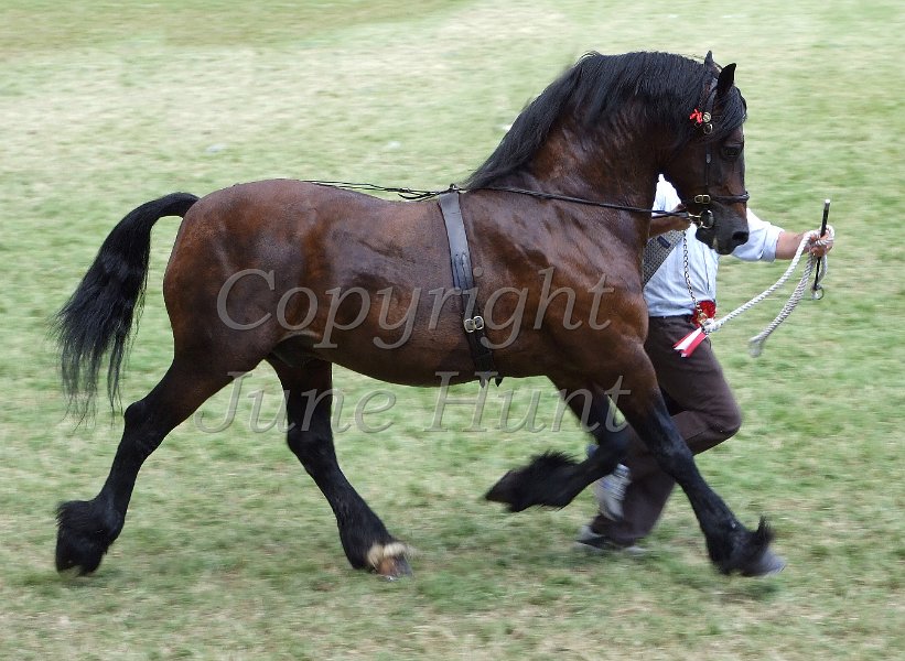
There are always a wonderful variety of displays in the main ring, http://www.rwas.co.uk/whats-on/ . One of the highlights is the pony club games, there are always some stunning performances by specialist display teams. Wednesday is Welsh Cob day, there's always a big cheer as these hefty horses thunder around the ring.
A wide range of organizations which work towards looking after the countrysides from various standpoints are represented in the countryside area. http://www.rwas.co.uk/countryside-care-area-1/
Anyone will say you need to spend all four days there to get around half of the displays, trade stands and activities, to sample just some of the food on offer, to watch performances in the various rings or to see the huge variety of animals shown.
If you plan to travel to Wales in the future, consider a day at the show, but plan your accommodation well in advance! Cambrian Safaris could of course provide or arrange transport from accommodation in the Aberystwyth area! At other times of the year, the Spring festival, also known as the Smallholdings and Gardens Show is held on the 3 rd weekend in May and the Winter fair is at the beginning of December.
See http://www.welshbreedsnews.co.uk/albums/Royal%20Welsh%20Show%202012/ for more images like the one below!

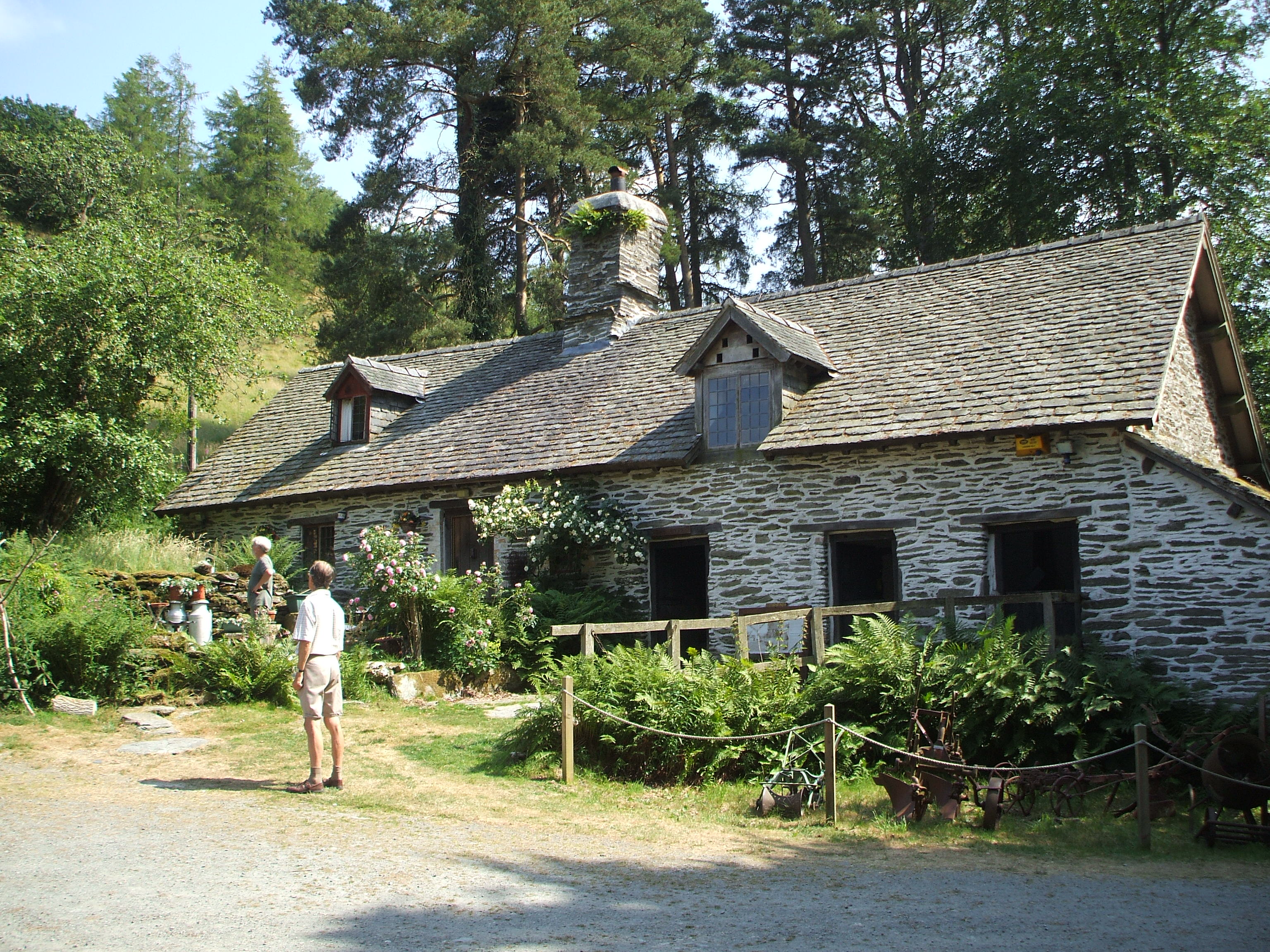
The sun has been shining for about 3 weeks now, and for the first time in about 7 years the grass is starting to dry off where the soil is thin on the rock. Gilfach nature reserve near Rhayader retains some freshness on the North and west facing hillsides.
The Radnorshire wildlife trust reserve ( http://www.rwtwales.org/index.php/radnorshire-wildlife-trust-reserves/gilfach ) is in a secretive side valley off the River Wye, a couple of miles up the A470 from Rhayader. http://goo.gl/oUUu0
The long house farm house was restored a few years ago and the lower half which would have provided shelter for animals is open to walk into and was quite cool on a warm day.
Above the hill opposite, Yr Wylorn, a Buzzard circled and a Peregrine soared, grasshoppers chattered and down by the stream a Dipper bobbed. If we had stayed until evening we would have seen Bats emerging from the old railway tunnel, but instead we headed off to the Elan Valley visitor centre to top up the stock of Cambrian Safaris leaflets, have an Ice cream and marvel at the variety of different Bicycles for Hire there. The old Railway routes there make great cycle paths. I'll write about the beautiful Elan Valley another time.
Writing from mid Wales... I've joined Americymru to post stories and pictures etc fresh from Mid Wales, and to promote 'Cambrian Safaris'.
This weekend is Rhayader Carnival, and next week the Royal Welsh Agricultural show, which I believe is the largest this side of the pond!
Looking forward to a trip around the Elan Valley tomorrow!
Something new something old? Its new for me to be writing on the Americymru Website, from the 'Old Country'!