Recently Rated:
Stats
Strata Florida Abbey, Ysbyty Ystwyth, Devils Bridge, Nanteos and the legend of the Holy Grail.
I often wondered why Ysbyty Ystwyth was so called, was there once a hospital there? Something to do with the mining industry and injured miners perhaps?
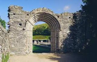
Strata Florida translates as the valley of the flowers, Strata Florida Abbey is a former Cistercian abbey situated just outside Pontrhydfendigaid, near Tregaron in the county of Ceredigion, Wales. The abbey was originally founded in 1164. http://cadw.wales.gov.uk/daysout/strata-florida-abbey/?lang=en
Devils Bridge. Its always amused me that the construction of the Bridge is attributed to the Devil in the local story, (see www.devilsbridgefalls.co.uk) but was built by Monks in the 11th century - the date quoted is 1087. This pre-dates the founding of Strata Florida by about 80 years, but the Bridge would have been used by monks from there to reach ranges at Ystumtuen, which later became part of the Nanteos Estate. This suggests Monks were influential in the area from the time of the Norman conquest.
Ysbyty Ystwyth gets its name from the Yspytty – run by the monastery, which was a place of hospitality, shelter and entertainment for visiting strangers when other houses of accommodation were unknown. The monastery was affluent enough to provide this, but there were restrictions upon who could stay there so they provided places for travellers – pilgrims perhaps- to rest on their travels. It is also possible that the name derives from the Knights Hospitallers who had extensive lands in the area.
Cwpan Nanteos, - the Nanteos Cup.
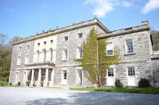
Legend has it that the Holy Grail found its way to Strata Florida via Glastonbury Abbey where Joseph of Arimethea took refuge fleeing persecution in Jerusalem. Centuries later when King Henry VIII waged war on the Catholic Monks, they fled the Abbey with the Grail to Nanteos Mansion where the cup was hidden for many years.
(The Nanteos Cup when examined was found to be a 500 year old kitchen cup made from Rowan wood, which is native to Wales. However, many still believe the legend, and it adds an air of mystery to the place).
Nanteos mansion is now a rather wonderful Country house hotel. http://www.nanteos.com/
Cambrian Safaris are developing a series of tours with Nanteos Mansion to explore the delightfully varied countryside of north Ceredigion and the Cambrian mountains along with the wonderfully varied history of the area.. These tours will explore the extent of the old Nanteos estate as well as the other former gentrified estates of the area which acquired huge tracts of upland at the disillusion of the monasteries by Henry VIII in 1534. The tours can include visits to Strata Florida Abbey, Devils Bridge and an old Lead mine and will feature snippets of history from Bronze age times to the present day.
 Cambrian Safaris can offer a tour which features a selection artisan food producers. Here is part 2 of the tour with food and drink journalist Qin Xie. ( www.qinxie.co.uk ). Her article can be found here; http://uk.lifestyle.yahoo.com/ceredigion-hidden-gem-heart-wales-173500149.html Part 1 was posted on here on 27th Feb.
The Ceredigion Taste trail features some very special small scale food producers. Recently Cambrian Safaris visited several of them with Journalist Qin Xie. What was obvious about them all was that their work was an art form, a combination of knowledge and feeling, what they do is their life. The emphasis is on producing a quality product which is done by keeping the business small and manageable in the same spirit which it began.
New Quay Honey Farm has about 600 bee hives across south Ceredigion. On the farm they have a shop and exhibition, and make mead from the honey. You will learn about the life cycle of the bees, how individuals work as part of a massive team. The Bee keeper will transfer part of a colony to a new hive when necessary and they will soon adapt to the new surroundings. each hive is checed just a few times a year. Honey is normally produced in May and July, and production can depend a bit upon the weather!Bees really are remarkable little creatures, and they can be seen - through glass- on their honey comb in a semi natural nest on a log and in a hive which can be opened up like a concertina to view the bees activities. http://www.thehoneyfarm.co.uk/
Rhydlewis Smokery and Trout farm .
Salmon, Trout, Cheeses, Bacon, Ham, Butter, Garlic and Chocolate are among the foods cured and smoked using traditional methods. The length of time taken to smoke a batch can depend upon the weather, so experience is key. Food preparation areas are kept immaculately clean and customers can view through a window, there is a small shop. Brian and Rose use only traditional curing methods, smoking very slowly in wooden chambers using oak saw dust to create the finest characteristic smokey taste.
The 3 acre lake is stocked with Rainbow and Brown trout for fly fishing only. The farm also has a small walk up rough shoot, d ay old Pheasants and Partridge are reared on site to seven weeks old for stocking purposes.
http://tastetrailwales.co.uk/en/producers/rhydlewis-trout-farm-smokery/
I first visited Glynhynod Farm in the mid 1980's for some of their Dutch style cheese which was laterbranded Teifi Cheese . The old byre where the cheese used to be made now houses D Mhle Distillery and a large new building was built some years ago for the cheese making and storage. http://tastetrailwales.co.uk/en/producers/teifi-farmhouse-cheese/ and http://tastetrailwales.co.uk/en/producers/da-mhile-distillery/
Toloja Orchards .
The business is primarily about apple juice and Cider, but cider brandy, elderflower and gooseberry jam, oak matured cider vinegar, chutneys are among other produce. Children Tom Lottie and James have contributed to the business in more ways than one, with home made curry kits, 2 teams of Reindeer for pulling sleighs at Christmas, Jimbos Jungle Juice and a petting farm and Heritage centre. http://www.welshcider.com/
For more info about Ceredigions artisan food producers, visit http://tastetrailwales.co.uk/ Much of the produce of the area can be bought at local farm shops, farmers markets and even in local supermarkets.
A Cambrian Safaris Taste trail tour would include stops on the coast and the back roads of the green rolling farmland and wooded valleys of the southern half of Ceredigion.
Ceredigion is a small county with an even smaller population, on the west coast of Wales it is the bit in the middle, separated from the main centres of population in the south and the main lines of communication which focus on North and south Wales.
The Ceredigion Taste trail features some very special small scale food producers. Recently Cambrian Safaris visited several of them with Journalist Qin Xie. What was obvious about them all was that their work was an art form, a combination of knowledge and feeling, what they do is their life. The emphasis is on producing a quality product which is done by keeping the business small and manageable in the same spirit which it began.
Felin Ganol Watermill in Llanrhystyd lay idle for 50 years before it was restored by its current owners for whom restoration and flour production has clearly been a labour of love. They started up the water wheel for us and poured in some grain, we went down stairs and the wholemeal flour began to flow. They told us about different grain and explained how they have come to understand not only the milling processes but also the maintenance of the ancient equipment, some of which dates back 400 years. They buy in grain from organic farms and mill grain grown locally by farms belonging to the University of Wales. The Mill building is a fascinating combination of structures which have been altered and adapted over the centuries with stone walls and huge beams pegged together. The huge wooden cog wheels transferring power from the water wheel to the mill stones are a remarkable feat of precision engineering. http://tastetrailwales.co.uk/en/producers/felin-ganol-watermill/
Penlon Brewery produces small batches of hand produced bottle conditioned beers with names like Ramnesia, Tipsy TupPale Ale and Ewes Frolic Larger, which are suitable for vegetarians and . High quality raw materials are used, one problem is that barley has to go to Devon to be malted as there is nowhere suitable in Wales.
Years of experimenting and personal experience have gone into producing recipes for 10 beers. The Brewers grains are feed to Shetland sheep who are raised for their wool. http://www.penlon.biz/
Llwynhelig Farm Shop began 30 years ago when surplus milk and veg from the farm was sold from a table top in a garage. Potatoes, salads and seasonal veg from the farm are sold along with 50 welsh cheeses a tremendous variety of home made cakes, pies, jams, chutneys, locally produced meat, chocolate, liqueurs, honey, beer, cider... almost all of the food producers on the Ceredigion taste trail feature here, among a total of around 130 producers most of whom come from within 40 miles.
13 Wales True Taste Awards for best retailer, home baking, local sourcing and sustainability and a Countryside Alliance Rural Oscar for best local food retailer are among many awards won over the years. http://www.llwynhelygfarmshop.co.uk/
A smokery, a cheese maker, a Distillery and a Honey farm - to follow!
For more info about Ceredigions artisan food producers, visit http://tastetrailwales.co.uk/
see also http://uk.lifestyle.yahoo.com/ceredigion-hidden-gem-heart-wales-173500149.html
Tasty Tour of Ceredigion Photo Slideshow

A View of the Rheidol Valley.
The University town of Aberystwyth lies on the west coast of Wales, half way down Cardigan Bay. It is the only sizeable centre of population in between Caernarvon in North Wales, Carmarthen to the south or Shrewsbury over the border 70 miles to the east.
A trip on the Vale of Rheidol Railway would make a very good introduction to the Rheidol valley. It runs for about 6 miles along the bottom of the valley to Capel Bangor, then begins to climb the side of the valley for a further 6 miles to Devils Bridge. As soon as the train pulls of the station, buildings of the National Library of Wales and the University can be seen on the hill.
For the first half of the trip, the valley is broad and the fields are grazed by cattle, some of it parkland of the Gogerddan Mansion which is now IBERS. (Institute of Biological, Environmental and Rural Sciences, which has its routes in the old grassland and plant breeding centre and the old Welsh Agricultural college). The Aberystwyth show is normally held here at the start of June.
As soon as Capel Bangor is passed, the train heads into the trees at the side of the valley, passing the Rheidol Riding Stables and begins the long climb to Devils Bridge, the twists and turns in the tracks alternately mirror the meanders of the river and skirt around the foot of steep side valleys, such as the one at Aberffrwd where the lane climbs steeply to the main road 800 feet above.
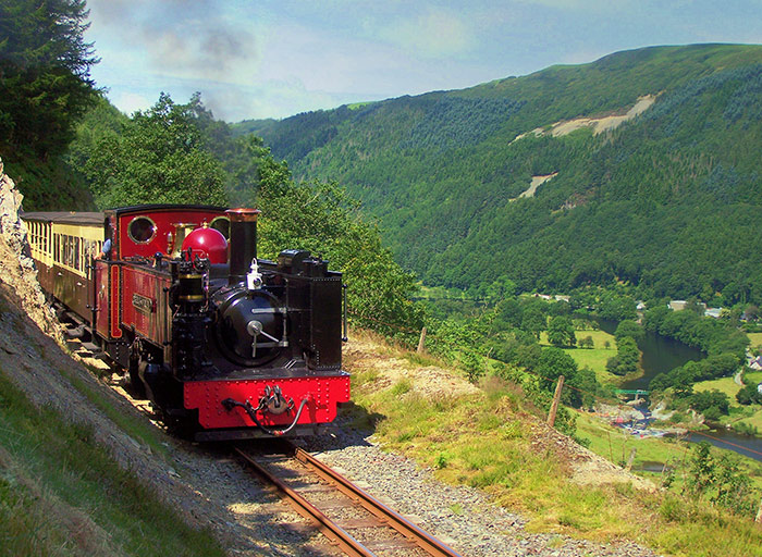
The Vale of Rheidol Railway with Rheidol falls below and the Stag on the hillside above.
The meandering Rheidol Reservoir is the next major feature in the valley bottom which catches the outflow from the hydro-electric power station, above which a mine spoil heap can be seen in the shape of a Stag. At the head of the reservoir are the Rheidol falls and fish Ladder and above here the railway passes through some of the surface workings of Rheidol united mines which connect with surface workings of a mine once known as 'Silver Mountain' which can be seen beside the A4120 above. In all these workings are almost 1000 feet deep.
Above the Rheidol falls the valley bottom continues to narrow (as does the road) until the waste heaps of the Cwm Rheidol mine are seen on the north side of the valley, ore was once lifted from here by a rope way to the railway line to be taken to Aberystwyth for export. Below here is a popular spot to bathe in the river and a footbridge crosses a narrow gorge.
As the train winds its way into Devils Bridge, the Rheidol valley is deep and lined with Oak woodlands, where it is thought that Red Squirrels and Pine Martens could exist. The valley turns a right angle to the north here, an example of the Geological phenomenon 'River capture'. Long ago, before the last Ice age, the upper reaches of the Rheidol were once the headwaters of the Teifi, which suffered losses to 2 rives cutting their gorges upstream under the ice.
Devils Bridge is known in Welsh as Pontarmynach, the 'Devils Bridge' was actually built by monks in 1087. This bridge supports the foundations of its replacement, built in about 1750, a bridge that was able to carry a carriage, and a modern bridge is now sitting above these. 2 spectacular walks start here to see the bridges, gorge and Waterfalls which William Wordsworth compared to Viamala in Switzerland. http://www.devilsbridgefalls.co.uk/index.php?page=109
North of Devils Bridge the Rheidol gorge heads for Ponterwyd where the upland country is more open and the upper Reservoirs of the Hydro scheme can be found.
Cambrian Safaris offers tours from Devils Bridge station to explore the upper reaches of the Rheidol valley and the surrounding hillsides from where there are stunning views back to the coast. It is possible to take a train from Aberystwyth at 10.30, arrive in Devils Bridge at 11.30, and enjoy a 4 hour tour and return in time for the train back to Aberystwyth at 4.15.
Apologies for taking a month to get on with part 2!
We continue the trip at Pontrhydygroes, once known as 'little Switzerland' the valley does have something of an Alpine feel here.
The village of Pontrhydygroes is spread out across the wooded hillside on the southern side of the river Ystwyth. Whether you approach from New Row or from down the Valley the Methodist Chapel dominates the village. Below the village, the river runs through a narrow gorge, and down stream enters a narrow V shaped valley. The Miners Bridge, a footbridge, rebuilt a few years ago, provides the only access to woodland walks opposite, without a lengthy detour. It replaces a bridge built by miners 150 years ago to connect New Row with the village and the Mines.
At the Bridge (Pont) there presumably used to be a ford (Rhyd) and I believe the cross (Groes) refers to the road junction. You have to head a little way up the hill to reach the main part of the village, on the left the Miners Arms Pub B+B and shop is now the focal point of the village, further up is Lisburn garage and 'Cwtch' Cafe.
In the crook of the bend in the road above Lisburn Garage sits the Count House, with steps from the road to a door where Miners once received their wages, and a balcony on the end where the bosses once sat, while the miners sat on benches in the yard below on 'setting day'. Work in different sections of the mine would be assessed and teams of miners would bid against each other to work in different parts of the mine. Under the bend in the road is the level Fawr, a tunnel begun in 1785, taking 9 years to drive of a mile to drain and ventilate Logaulas Mine, over the following 30 years it was driven a mile or so further for access to 3 more mines. It is said that at sun set on mid summers day, the sun shines straight along the tunnel for some distance for a few moments.
Further up the road is Ysbyty Ystwyth with its Cornish style Church, beyond here you are up out of the Ystwyth Valley and heading for a fantastic view over Tregaron bog (Cors Caron) and the upper Teifi Valley which runs down to Cardigan / Aberteifi.
Returning to the Bridge at the bottom of the Hill, a lodge guards the lower entrance to The Hafod estate and the road heads off up the side of the valley. If it were not for the former mansion, I'm certain the road would continue up the bottom of the valley to Cwmystwyth village but instead climbs high up the side for traffic to bypass the heart of the estate. The road splits part way up the hill, the left going to Devils Bridge and the right climbing high above the estate and zigzagging its way along the upper edge of the valley. Before it emerges from the trees, a small Cornish style church is seen to the right of the road, belonging to the former great Mansion. Walks through the Hafod estate begin here. As the road emerges from the forest, it begins to head away from the valley, towards Pwllperian farm, but the main route forks right to continue to Cwmystwyth. As the village is approached, the valley bottom is broad and contains the green meadows of several farms and the sweeping curves of the river .
Pwllperian. (the following paragraph is taken from www.pumlumon.org.uk )
For more than 80 years researchers at Pwllpeiran have worked to improve the viability of farming the uplands of Wales. Their studies have helped hill farmers care for their livestock and manage their land more efficiently. Pwllpeiran has a long and distinguished record of involvement with change and development in the Welsh uplands and was once part of the famous Hafod Estate of Thomas Johns. In the 1930s it became the centre of Sir George Stapledons pioneering Cahn Hill Improvement Scheme before becoming in 1955 a Ministry of Agriculture, Fisheries and Food Experimental Husbandry Farm.
This had two objectives:- Firstly to demonstrate integration between agriculture and forestry and secondly to develop practical systems to increase the output from Welsh Mountain Farms, as a way of maintaining rural populations and incomes.
Over a thirty year period, Pwllpeiran increased its agricultural output dramatically and its systems were widely taken up by farmers but lead to serious impacts on both landscape and the environment particularly overgrazing .
Today, output is no longer so important and the uplands are increasingly being managed for multiple objectives with the aim of creating a more diverse rural economy which can provide jobs and stable rural communities. This change in emphasis away from production per se towards far more environmentally sustainable system, is reflected in Pwllpeirans current activities.
Pwllperian has recently become part of Aberystwyth University's Institute of Biological, Environmental and Rural Sciences (IBERS)
Cwmystwyth village is little more than a scattering of farms and houses, as soon as you pass through the valley narrows, the sides are clad with oak woodlands. Emerging from the woodland is the most dramatic change of scenery you will find almost anywhere. The Mines of Cwmystwyth have huge waste tips, various ruined buildings, tramroads, leats, adits, and shafts. High up the hillside copper was mined here around 4000 years ago. Most of the evidence that can be seen now is from mining which developed through medieval times and peaked in the second half of the 19 th centuary, struggling on until 1921. Almost a mile of the valley side is covered in bare rock, from the crags of Graig Fawr so the spoil heaps at the edge of the river, it is visible on google earth / maps when you have the whole of Wales on your screen. http://goo.gl/maps/oaTyd A closer look at the right hand half of this view shows the spoil heaps from the Bronze age workings on Copper hill and probably the most impressive example of 'hushing' in Britain.

I'm sure most people passing through between here and the Elan valley beyond see the old mines as a dreadful mess and nothing more, which is a shame because there is a wealth of stories to be told about the people who lived and worked in conditions to play their part in the development of everything we take for granted today. I'll come back to this subject one day.
At the head of the Valley is Tyllwyd farm, which has just constructed a small hydro electric scheme using the old mine leat to carry a pipe line. There is also a Campsite here and Esgair wen holiday cottage. The road climbs from here up to the Elan Valley Estate.


The Ystwyth. part 1.
The Ystwyth is the southern of the 2 rivers which meet the sea at the harbour of Aberystwyth.
The Harbour was developed in the 18 th and 19 th centuries to export the lead and zinc ore from the mines some 10 or 15 miles in land to south Wales for smelting.
The northern of the 2 rivers, the Rheidol, holds the largest Hydro Electric scheme in Wales or England, is followed by a 12 mile narrow gauge railway climbing the side of the valley, has Oak woodlands clinging to its sides and from about 6 miles inland the valley narrows and around the Devils bridge area the valley is very steep sided and contains a deep gorge and a famous waterfall, but more about that another time!
The Southern valley is the Ystwyth, it is a remarkable valley because in its length of little more than 15 miles there are 6 or 7 distinctly different landscapes, with some dramatic changes along the way.
Pen Dinas Iron Age Hill fort stands guard high above the short tidal reaches of the Ystwyth, the first of many above the sides of the valley. Heading up stream the river starts along behind a shingle bank, but it soon turns inland. The valley bottom here is wide and open and green, millennia ago it could have been an estuary, cut off by the shingle bank. The route of the old Carmarthen railway line skirts the bottom of the hill, following the river inland. It is possible to follow the route of the old railway line some 10 miles before it leaves the valley, it is a cycle route now.
For 8 miles or so the valley is wide with gently sloping sides and the fields are green pastures all year around. If you take the road from Aberystwyth which takes the more direct route to Trawscoed, you will pass the Nanteos Mansion, with a story about the holey grail, it is now a very smart Hotel. ( www.nanteos.com ) It has some intriguing ghost stories too! ( http://www.strangedayz.co.uk/2008/08/ghosts-and-holy-grail-nanteos-mansion.html )
At New Cross there is a tantalizing glimpse of the hills ahead, before plunging down into the valley again.
Alternatively if you stick closer to the course of the river from Aberystwyth you pass through the Village of Llanilar, which holds a wonderful (agricultural) show at the beginning of august every year. It is the only sizeable village in the whole valley, apart from Llanfarian at the junction with the main coast road.
The Ystwyth Valley looking towards Llanilar. The sea can be seen on the horizon.
9 miles from Aberystwyth is the Trawscoed estate, with its huge mansion, seat of the Lisburnes for 800 years, was a massive, 45,000 acres. http://www.trawsgoed-estate.co.uk/2.html There is a story of a poacher, Will Cefn coch, (William Richards) who shot Gamekeeper Joseph Butler in1868. He was kept hidden in various houses for some time, and eventually escaped to Ohio where he lived for the rest of his life without being charged for the crime. (Welsh Murders Vol 1: 1770 - 1918 By Peter Fuller and Brian Knapp.
Trawscoed mansion.
The site of the mansion marks the beginning of the first dramatic change in the character of the valley, it starts to narrow, and after a mile or so the sides are steep and heavily forested. The valley bottom instead of being wide and green is now narrow and stony, covered in gorse bushes. The wide B road we had been following turns south for Tregaron, now a minor road follows the valley bottom between the hills. As you progress you can see why the area around Pontrhydygroes used to be known as little Switzerland it is a little Alpine in character.
Above Pontrhydygroes, the valley widens out a little and a great variety of trees line the hillsides. The Hafod Estate is a magical place, its wonderful and tragic story is told in the book Peacocks in Paradise by Elizabeth Inglis Jones. http://www.hafod.org/
East of Hafod the valley widens for Cwmystwyth Village, narrows again where the Cwmystwyth mines can be found, and then disappears up into the hills.
Part 2 of this exploration up the valley will feature the upper half of the valley in more detail.

Cambrian Safaris is a new business, we have only been up and running a few months and are working hard trying to make ourselves known both in Wales and abroad! The idea has been with us for several years, we have always enjoyed showing visitors family and friends the sights of the area, and 7 years of ownership of an old military 'Lightweight' Land Rover meant we have found our way around most of the back roads, both surfaced and unsurfaced, of north Ceredigion and the Cambrian mountains.
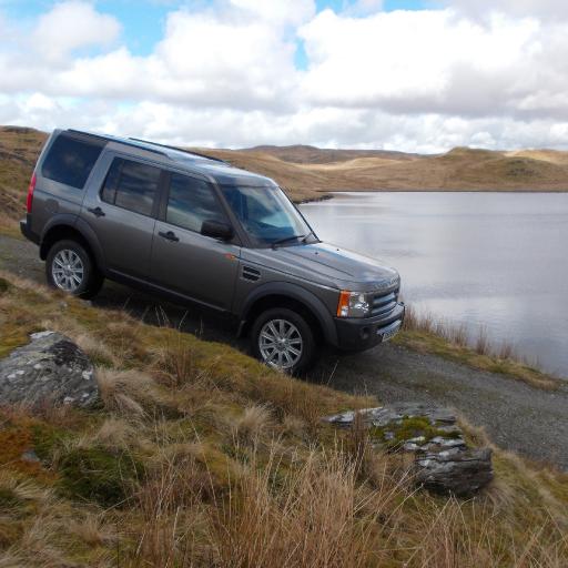
At first we thought we'd be using an old style Land Rover, as you might expect on safari in Africa, but we soon decided to go for something which would give our guests a more comfortable ride. The Land Rover Discovery 3 is practically as good as a Range Rover, and can carry 6 passengers. We did not chose a Land Rover because we want to drive a lot of rough tracks / 'green lanes' etc, but more for space and comfort, and the view, which turned out to be a lot better in the 'Disco' than in a conventional Land Rover.
There are 3 main areas which we cover in our tours, 1) The Rheidol and Ystwyth Valleys in land of Aberystwyth, 2) the Elan Valley Reservoirs and 3) a tour of the southern part of the Cambrian Mountains.
The UK as a whole has a greater diversity of geology, geography and different landscapes than anywhere else in the world, for such a small area. In Wales, the National parks in the North and the south seem to hog all the limelight, the Cambrian Mountains were proposed as a National Park but the plan was rejected. The Cambrian Mountains are, however, an equally special area with a very dramatic, diverse landscape, with high hills, deep valleys, tremendous views and an abundance of wildlife. In fact the management of some of the upland areas, such as around the Elan valley estate and some of the forestry plantations is gradually being managed more and more for the benefit of wildlife and for amenity value.
The northern part of Ceredigion, or Cardiganshire as it used to be known is crammed full with steep sided valleys, is very green and rich in history. The tops of the Mountains here are mostly 1,500 2,000 feet high, Plynlumon is the highest point in Mid Wales at 2,468ft. The Welsh name Pumlumon translates as 5 peaks, although it mystifies most people where they all are as there are really only 2. The name Plynlumon derives from the Roman name, Plumbilumon which means I believe lead boundary. The Romans certainly knew there was lead in them there hills, and mined in around 30 places in the area. The mining developed slowly through medieval times and right up to the second half of the 19 th Century when it briefly boomed and died. In most cases the mining remains are discrete, there are just a handful of notable exceptions. The mining left its marks in other ways, but unfortunately it is generally regarded as something dirty, dangerous, scary, and to be avoided... I'll write a couple of pieces about the mining in the near future and try to show a different story.
The tours in North Ceredigion feature the contrast between the gentrified estates and the scattered small holdings and farmsteads where people tried - and still do try - to eek out an existence in the hills. It features the mining remains of the old Cardiganshire Silver Lead mining industry, and is intended to surprise and delight with sudden dramatic views from steep back roads and mountain routes. Nant y Moch Dam is over 1000 feet above sea level, the hydro electric power station in Cwm Rheidol is about 800 feet below. There are remote lakes, isolated farmsteads, Red Kites over head, hanging oak woodland clinging to the steep valley sides with Redstarts and Pied flycatchers, forestry and open moorland. We follow in the footsteps of artists, poets, writers, and the aristocracy, who came to marvel at the rugged landscape and 'hunt' out the best spots for a painting. At a time when it was fashionable to take a tour of Europe, Aberystwyth was becoming a genteel seaside resort and Mid Wales was at the heart of the Picturesque movement. During the second half of the 18th century the members of the English upper classes with time on their hands took the 'Grand Tour' of Europe. Some however began to discover that places like Mid Wales had the landscape qualities they were looking for to delight and inspire.
The 'mountain road' tour passes through one of the remotest parts of Wales (or England). The mountain road is a single track former drovers route running for 20 miles between the lush grazing lands of the Teifi valley in the west and the Wye valley on route to Hereford to the East.
It climbs to 1580 feet, passes through forest and over open moorland, plunging into the deep valleys feeding the long fingers of the Llyn Brianne reservoir and passing through the upper Irfon Valley. The tour circles to the south with stunning views of the Brecon Beacons and the Llyn Brianne reservoir.
The Elan Valley tour passes alongside a sequence of 5 reservoirs and from wooded valley sides to high open moorland, this tour will take you past the dams and over 2 high upland routes with views to Snowdonia, the Brecon Beacons and possibly Pembrokeshire. The Elan valley is known as the 'Welsh Lake district', the 5 large reservoirs were built in the 1890's and 1950's supply water to the Midlands.
Although the distances and heights above sea level are distinctly unimpressive compared to other parts of the world, the beauty of mid Wales lies in the magical way in which the landscape can change completely every few miles, there is no need to travel vast distances, wonderful variety can be found within 20 30 miles in each direction.
Over the next few months we hope to develop a range of 'package tours with different options for accommodation, tours, visits and even airport pick ups. Watch this space! In the mean time I will describe parts of the areas the tours pass through in more detail.

Hi everyone,
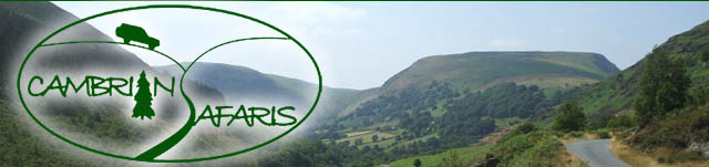
Cambrian Safaris provides excursions into the Cambrian Mountains in a Land Rover Discovery to enjoy fantastic views and scenery, local history and wildlife. We will pick you up from your accommodation or arrange a meeting point.
We are able to offer airport pick up and arrange accommodation for international visitors, or provide recommendations and contacts if you wish to make your own arrangements.
Today Cambrian Safaris took an Australian visitor for a trip around Devils Bridge, the Hafod Estate, Pontrydygroes, Ysbyty Ystwyth, Ystumtuen, Bwlch Nant Yr Arian, (at 2.30 for the Red Kite feeding), Cwmerfyn, Cwmsymlog and the lakes at Pendam, Bleanmelindwr and Syfydrin. These places are all about 10 -15 miles in land of Aberystwyth. It was a drive around some small back roads, with some fabulous views in very mixed weather - sunshine and heavy rain with some thunder and lightening. The development of the 'Picturesque' Hafod estate was featured, as was the mining industry which left its mark on the areas landscape. I'll talk about all of these and more in future blogs, both as me, Richard Smith, and in write ups of Cambrian Safaris tours.